How Green is My Matunga
Thanks to Jehangir Sorabjee's Above Bombay book, I could see how green Matunga is
Background: This was published on 20 October 2005, preceding the “Aamchi Mumbai” (3.1) piece by almost 11 months. Jehangir had been kind enough to send me .jpgs of the aerial photographs he had taken of Matunga in advance, prior to the publication of his book.
Here is the archive link.
I later wrote another piece in Sep 2006, once the book was launched, "Aamchi Mumbai".

For some time now, I have begun to believe that I know almost everything there is to know about Matunga. And then last week, I saw Matunga from such a completely different perspective, that it punctured my balloon of presumptuousness, virtually immediately.
Jehangir Sorabjee, a friend and colleague, has been clicking different parts of the city, for the last seven odd years, from the sky. Literally! Whenever he gets the chance, he gets into a chopper and flies over the city, shooting pictures from overhead vantage points. He emailed me two pictures of Matunga, centred over King’s Circle, one from the north end, just above the flyover and one, as if he was hovering above Don Bosco.
Words cannot really replace the impact of the visual imagery, but until his book “Above Bombay” is out in December, they will have to do. King’s Circle takes centre-stage, seen as a round, completely green island, flourishingly verdant, rimmed by a grey concrete road, in turn rimmed by squat, flat buildings, all around the same height. Radiating from the circle, in a Beybladish manner, are seven spidery arms, which are the seven roads, including the main arterial Ambedkar road, which in turn resembles the quadriceps apparatus, the two parts of which appear interrupted by the sesamoid patella-like circle.
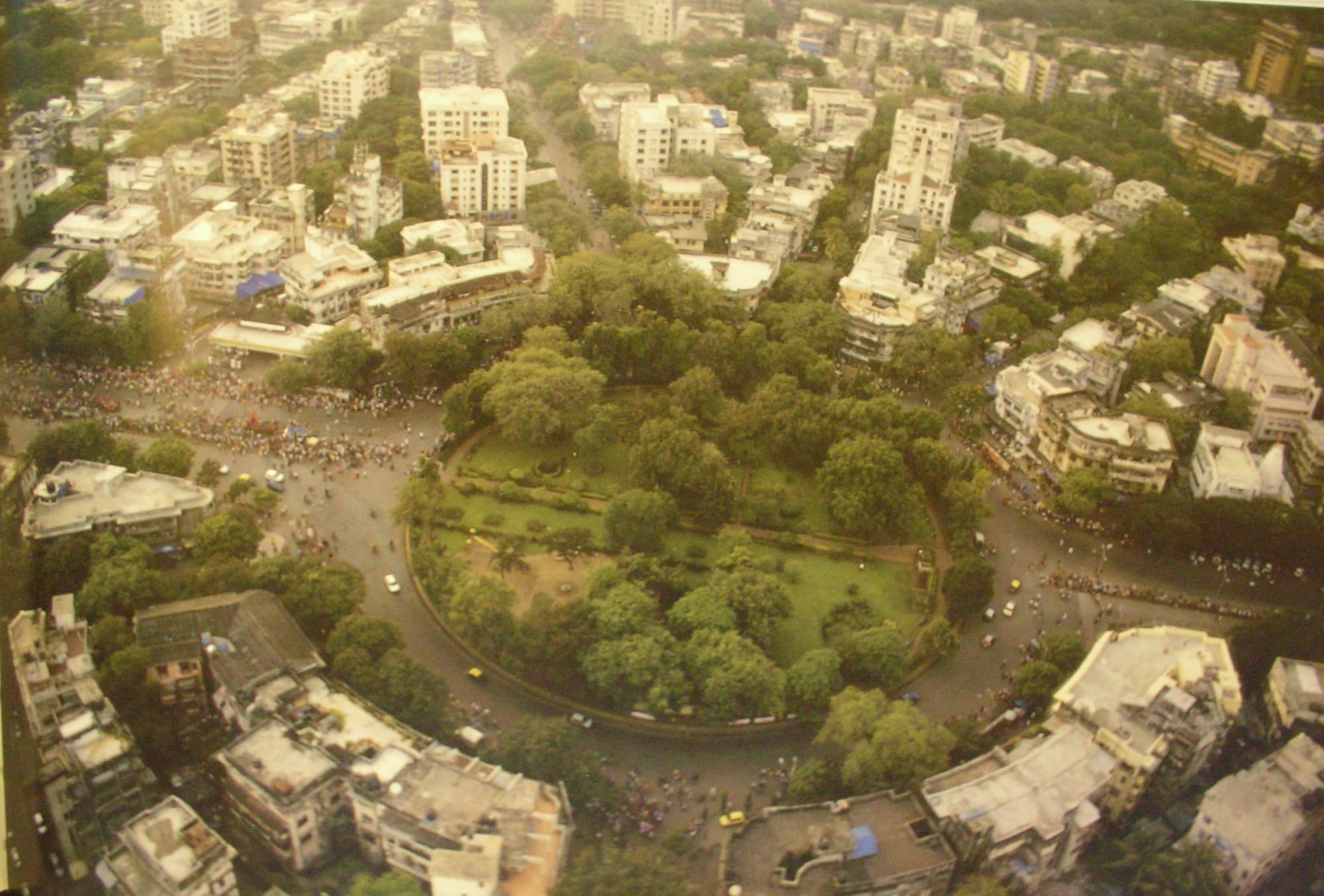
More importantly, except for the main arterial Ambedkar road, all the other five exits are tree-lined and green, to the extent that you can barely see the concrete, and their existence is apparent only because of the cars and people.
He then sent me one more high-resolution photograph centred over the Matunga railway tracks looking east. In this picture, the entire Greater Matunga area looks like a forest, the monotony as if broken by the buildings and the larger arterial roads, which are the only ones where you can see the concrete on the roads. You actually get a sense of the planning and thought that must have gone in at the time when this area was being developed.
And then, as Jehangir mentioned, you come down to ground reality; to the chaos and the filth, the paan-streaks and spittle-dabs … and it makes you want to cry. The beauty of an overhead shot is that it masks the griminess of the unpainted buildings with their peeling plaster and rain-water streaks and funnily, in an aerial shot, the drab gray, which is the hallmark of virtually all our landlord-owned buildings, actually helps make the green stand out, in contrast.
I tried to see if King’s Circle would show up on Google Earth in a similar manner, but it looks as if Google Earth is run by South Mumbaiites. All the lovely, high-resolution imagery ends at Mahalaxmi, and the rest of Mumbai is seen with such low-resolution that you can barely just make out the main arterial roads. But even here, the one thing that stands out among all the brown and grey terrain, is the green blob that is King’s Circle / Matunga.
Bhavin's Writings Newsletter
Join the newsletter to receive the latest updates in your inbox.